See Further: Scientists Achieve Single-photon Imaging over 200km
A research team led by Professor PAN Jianwei and Professor XU Feihu from University of Science and Technology of China achieved single-photon 3D imaging over 200 km using high-efficiency optical devices and a new noise-suppression technique, which is commented by the reviewer as an almost heroic attempt at single photon lidar imaging at very long distances.
Lidar imaging technology has enabled high precision 3D imaging of target scene in recent year. Single photon imaging lidar is an ideal technology for remote optical imaging with single-photon level sensitivity and picosecond resolution, yet its imaging range is strictly limited by the quadratically decreasing count of photons that echo back.
Researchers first optimized transceiver optics. The lidar system setup adopted a coaxial scanning design for the transmit and receive optical paths, which can align the transmitting and receiving spots more precisely and achieve higher-resolution imaging in comparison with tradition method.
To differentiate weak echo signal from strong background noise, the team developed a single-photon avalanche diode detector (SPAD) with a 19.3% detection efficiency and a low dark count rate (0.1kHz). Further, researchers coated telescope to achieve high transmission at 1550 nm. All these improvements achieved higher collection efficiency than before.
Researchers also adopted an efficient temporal filtering technique for noise suppression. The technique can reduce the total number of noise photon counts to be about 0.4 KHz, which is at least 50 times smaller than previous works.
Experiment results showed that the system can achieve accurate 3D imaging at up to 201.5 km with single-photon sensitivity.
This work could provide enhanced methods for low-power, single-photon lidar for high-resolution active imaging and sensing over long ranges and open up a new road for the application of long-range target recognition and earth observation.

Satellite image of the long-range active imaging experiment over 201.5 km. (Image by LI Zhengping et al.)
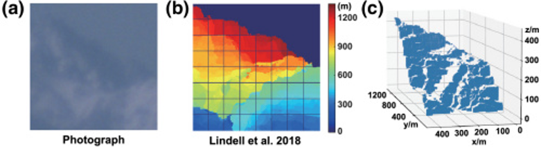
Reconstruction results for a scene over 124.0 km. From left to right are: photo taken using visible light, reconstructed depth image from method proposed by Lindell et al. and the real depth profile. (Figure by LI Zhengping et al.)
(Written by CAI Bohan, USTC News Center)
Back